Back Bieke Shankou CEB گردنه بئیک Persian Passo Beyik Portuguese Bieke Shankou Swedish 排依克山口 Chinese
| Beyik Pass | |
|---|---|
| Elevation | 4,742 m (15,558 ft) |
| Location | China–Tajikistan border |
| Range | Sarikol_Range, Pamir Mountains |
| Coordinates | 37°18′N 75°00′E / 37.3°N 75°E |
 | |
| Beyik Pass | |||||||
|---|---|---|---|---|---|---|---|
| Chinese name | |||||||
| Traditional Chinese | 排依克山口 | ||||||
| Simplified Chinese | 排依克山口 | ||||||
| Literal meaning | Payik Pass | ||||||
| |||||||
| Alternative Chinese name | |||||||
| Traditional Chinese | 别伊克山口 | ||||||
| Simplified Chinese | 别伊克山口 | ||||||
| Literal meaning | Beyik Pass | ||||||
| |||||||
| Tajik name | |||||||
| Tajik | Ағбаи Беик[verification needed] | ||||||
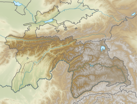
The Beyik Pass, also written and Payik Pass and Bayik Pass,[1] is a mountain pass in the Sarikol Range between Gorno-Badakhshan Autonomous Province in Tajikistan and the Taghdumbash Pamir region of Tashkurgan Tajik Autonomous County in Xinjiang, China. It lies at an elevation of 4,742 metres (15,558 ft).[2] There is an ethnic Kyrgyz village on the Chinese side with the same name (Chinese: 排依克村),[3] though the village is more commonly referred to by a different name in Chinese (Chinese: 阿特加依里村) and Beyik is reserved for the border guard outpost.[4]
- ^ Stein, M. Aurel (1907). Ancient Khotan: Detailed Report of Archaeological Explorations in Chinese Turkestan. Vol. 1. Oxford, UK: Clarendon Press. p. 31.
the Payik or Bayik Pass is the most frequent and easiest
- ^ Cite error: The named reference
border_agreementwas invoked but never defined (see the help page). - ^ 杨雪梅 (2016-09-09). "穿越瓦罕走廊(且行且思)" [Through the Wakhan Corridor]. people.gov.cn (in Chinese). People's Daily. Archived from the original on 2017-02-05. Retrieved 2017-02-05.
这里是瓦罕走廊第一村——排依克村
- ^ 赵戈 (2016-06-13). "瓦罕走廊转场日记". xj.xinhuanet.com (in Chinese). Xinhua News Agency. Archived from the original on 2017-02-05. Retrieved 2017-02-05.
瓦罕走廊中国境内唯一的村庄--阿特加依里村

